Veluwemeer Aqueduct: The Engineering Marvel in the Netherlands That Bends the Rules of Water and Road Transport

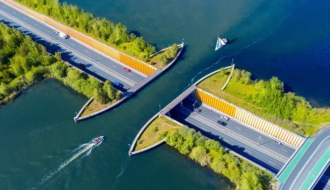
The Veluwemeer Aqueduct stands as a remarkable testament to modern civil engineering, challenging conventional architectural norms by allowing cars to drive seamlessly beneath a navigable waterway. Located in the town of Harderwijk in the eastern part of the Netherlands, this unique structure—officially known as the Veluwemeer Aqueduct—reshapes how transportation planners approach the intersection of road and water traffic. Opened to the public in 2002, the aqueduct connects the mainland city of Harderwijk to Flevoland, an artificial island, while simultaneously bridging the waters of the Ijssel River and the Veluwemeer lake. Rather than relying on traditional suspension bridges or costly ferry systems, Dutch infrastructure designers opted for a visionary water bridge that has since transformed from a logistical solution into an internationally recognized landmark.
Engineering Conception and Construction Background
The genesis of the Veluwemeer Aqueduct dates back to regional planning initiatives aimed at improving traffic connectivity between the mainland and Flevoland, a province established through land reclamation in the mid-20th century. As traffic volume between Harderwijk and Flevoland steadily increased, regional authorities faced a critical dilemma: construct a high-clearance bridge or a deep underwater tunnel for vehicular traffic, or establish a movable bridge that would inevitably disrupt the constant flow of maritime vessels.
Civil engineers concluded that traditional bridge construction would be excessively expensive and aesthetically disruptive to the flat Dutch landscape. Furthermore, a standard drawbridge would create persistent traffic bottlenecks during peak commuting hours and heavy boating seasons. The decision to construct a navigable aqueduct offered a dual-purpose resolution. By routing the roadway beneath a shallow body of water, engineers ensured that vehicle traffic and boat traffic could operate simultaneously without interference, completely eliminating wait times for either commuters or sailors.
Architectural Specifications and Structural Design
Spanning 25 meters in length and 19 meters in width, the Veluwemeer Aqueduct is deceptively compact yet immensely strong. The water channel resting above the vehicular tunnel is maintained at a shallow depth of approximately 3 meters, which is optimal for small watercraft, leisure boats, and local maritime transport. To ensure the absolute safety of the roadway below, the edges of the aqueduct are reinforced with heavy-duty steel sheet piles and robust concrete barriers designed to prevent water overflow and structural seepage.
Beneath the aqueduct lies a 17-meter-long underwater roadway tunnel designated for vehicular traffic. Flanking both sides of the motorway are dedicated lanes for pedestrians and cyclists, safely separated from automotive traffic by concrete barriers and protective railings. This thoughtful integration of multi-modal transportation allows walkers and bicyclists to traverse the aquatic barrier safely while taking in panoramic views of the surrounding lake and boat traffic passing directly overhead.
Financial Analysis and Cost-Efficiency
The construction of the Veluwemeer Aqueduct required a capital investment of approximately USD 61 million. While this figure represents a substantial public expenditure, municipal and national transport authorities defended the budget by conducting long-term cost-benefit analyses comparing the aqueduct to alternative infrastructure models.
According to civil infrastructure assessments, building a conventional suspension bridge capable of accommodating heavy commercial and passenger vehicles while maintaining sufficient clearance for tall ships would have cost significantly more in both initial construction and ongoing maintenance. Additionally, an aqueduct minimizes mechanical failure risks associated with drawbridges, thereby reducing long-term operational and repair expenditures. The investment has proven economically sound, as the route currently accommodates an average of 8,000 vehicles daily, serving as a vital economic artery for the region.
Integration into Flevoland and Regional Development

The strategic placement of the Veluwemeer Aqueduct is intrinsically linked to the development of Flevoland, the youngest province in the Netherlands and the site of one of the world’s most ambitious land reclamation projects. Reclaimed from the IJsselmeer in the 20th century, Flevoland requires robust and efficient transportation links to integrate its agricultural, residential, and commercial zones with the rest of the Dutch mainland.
The Veluwemeer lake and surrounding wetlands also function as vital ecological and cultural nature reserves, hosting diverse aquatic fauna and migratory bird populations. Regional planners had to ensure that the construction of the aqueduct preserved the natural hydrology and ecological integrity of the area. Consequently, the low-profile design of the aqueduct minimizes visual intrusion on the horizon, allowing the natural landscape to remain largely unobstructed while accommodating high volumes of modern traffic.
Official Responses and Public Reception
Since its inauguration in 2002, the Veluwemeer Aqueduct has garnered widespread acclaim from urban planners, architects, and international travelers alike. Municipal authorities in Harderwijk have reported overwhelmingly positive feedback from daily commuters, who praise the seamless flow of traffic and the absence of congestion points typically found at waterway crossings.
Maritime operators have similarly lauded the design, noting that commercial and recreational vessels can navigate the Ijssel River and Veluwemeer lake system without restriction or adherence to rigid bridge-opening schedules. The absence of vertical clearance limits for ships—aside from the natural draft depth of the 3-meter channel—provides unprecedented flexibility for waterborne commerce and tourism.
Global Tourism and Cultural Impact
Beyond its primary function as a civil engineering triumph, the Veluwemeer Aqueduct has evolved into a prominent tourist attraction. Aerial photography and drone footage of the structure—where automobiles appear to drive beneath a floating body of water—have frequently gone viral on global social media platforms, drawing curious travelers, photography enthusiasts, and engineering students to Harderwijk.
Local tourism boards have capitalized on the structure’s unique visual appeal, promoting the surrounding lake area as a recreational destination for boating, cycling, and nature observation. Visitors frequently utilize the pedestrian and bicycle pathways integrated into the tunnel structure to experience the surreal sensation of walking beneath a navigable waterway.
Broader Implications and Future Infrastructure Trends
The success of the Veluwemeer Aqueduct has broader implications for modern civil engineering, particularly in low-lying delta regions facing similar geographical challenges. As nations contend with rising sea levels, increased urban density, and the necessity for efficient multi-modal transportation networks, innovative aquatic architecture offers a viable alternative to traditional bridge and tunnel designs.
Infrastructure experts suggest that projects modeled after the Veluwemeer Aqueduct could serve as blueprints for coastal cities and island nations seeking to balance maritime navigation rights with high-capacity road networks. By prioritizing integrated spatial planning and resource efficiency, the Dutch engineering sector has once again demonstrated its global leadership in water management and structural innovation, cementing the Veluwemeer Aqueduct as an enduring milestone of 21st-century civil design.