The Architectural Marvel of Veluwemeer Aqueduct: How a Dutch Water Bridge Redefined Modern Civil Engineering and Traffic Management

When modern civil engineering intersects with innovative architectural design, the results often transcend mere functionality to become landmarks of human ingenuity. Among the myriad engineering marvels scattered across Europe, the Veluwemeer Aqueduct in the Netherlands stands out as a striking example of defying conventional infrastructure norms. Opened to the public in 2002, this unique navigable aqueduct creates an optical illusion that appears to challenge the laws of physics, offering a solution to traffic congestion that prioritizes both maritime and terrestrial commuters. Situated in Harderwijk, in the eastern part of the Netherlands, the structure connects the mainland to Flevoland—the largest artificial island in the world—while seamlessly facilitating the movement of boats, cargo vessels, vehicles, cyclists, and pedestrians.
Main Facts and Structural Overview
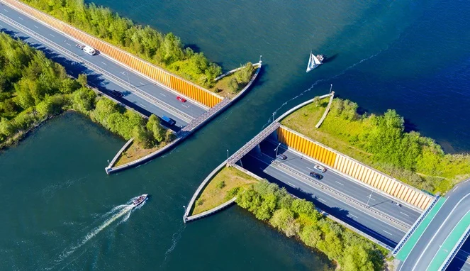
The Veluwemeer Aqueduct, locally known as a waterbrug, spans 25 meters in length and 19 meters in width, holding a shallow depth of approximately 3 meters of water. Unlike traditional bridges that elevate road traffic above waterways, the Veluwemeer structure reverses the paradigm by carrying the waters of the Veluwemeer lake over a sunken highway, designated as the N302 road. Beneath this flowing body of water lies a 17-meter-long underwater vehicular tunnel.
Designed primarily to connect the IJssel River and the Veluwemeer lake, the aqueduct allows small recreational boats, yachts, and commercial watercraft to pass continuously without the interruptions typically caused by drawbridges or lock systems. Meanwhile, the subterranean highway beneath accommodates an average of 8,000 vehicles daily. Flanking both sides of the vehicular roadway within the tunnel are dedicated pedestrian pathways and cycling lanes, protected by robust safety barriers to ensure the security of non-motorized commuters navigating between the city of Harderwijk and the province of Flevoland.
Historical Context and Chronology of Development
The conceptualization and eventual construction of the Veluwemeer Aqueduct emerged from decades of regional urban planning challenges in the Netherlands. Flevoland, reclaimed from the IJsselmeer as part of the ambitious Zuiderzee Works, officially became a province in 1986. As the population and economic activity of the region expanded rapidly, transportation links between the mainland and the newly formed island territories experienced severe bottlenecks.
By the late 1990s, regional authorities faced a critical dilemma regarding transportation infrastructure across the Veluwemeer lake. Planners evaluated three primary options: constructing a traditional high-level suspension bridge, implementing a complex system of locks and drawbridges, or building a navigable aqueduct.
A conventional high-level bridge would have required steep inclines unsuitable for heavy freight transport during winter ice conditions, in addition to imposing a heavy aesthetic impact on the pastoral Dutch landscape. Conversely, a drawbridge system would have caused chronic traffic gridlock for both terrestrial vehicles and marine traffic, given the high volume of recreational boating in the region.
Engineering assessments ultimately favored the aqueduct design. Construction commenced around the turn of the millennium, culminating in the official opening of the Veluwemeer Aqueduct in 2002. The project required meticulous hydrological calculations, steel pilings to reinforce the structure, and advanced water-management systems to ensure that the aquatic layer above remained stable and completely separated from the dry tunnel environment below.
Financial Data and Economic Implications
The construction of the Veluwemeer Aqueduct represented a substantial financial investment for the Dutch government, with total development costs reaching approximately $61 million USD. Despite the significant initial capital expenditure, transportation economists and civil engineers defended the budget as a highly cost-effective long-term solution compared to alternative infrastructure proposals.

Maintaining a conventional drawbridge network requires continuous mechanical operation, ongoing electrical power, dedicated staffing for bridge tenders, and frequent maintenance of heavy lifting machinery. Furthermore, traffic delays caused by opening bridges incur indirect economic costs through lost productivity and increased fuel consumption for idling motorists. By contrast, the passive hydrodynamic design of the aqueduct eliminates mechanical failure risks for the waterway itself, requiring maintenance focused primarily on standard structural inspections, drainage systems, and pavement upkeep in the subterranean roadway.
The financial efficiency of the project also extends to the regional tourism and recreation sectors. The Veluwemeer lake area functions as a vital cultural and natural reserve, supporting diverse local fauna and attracting thousands of domestic and international visitors annually. The uninterrupted flow of marine traffic enhances the appeal of Harderwijk and Flevoland as premier destinations for boating enthusiasts, indirectly stimulating local hospitality, retail, and marine service industries.
Official Responses and Engineering Assessments
Civil engineering associations and municipal authorities in the Netherlands have widely praised the Veluwemeer Aqueduct as a masterclass in pragmatic urban design. When the project was finalized, Dutch infrastructure planners emphasized that the primary objective was to ensure uninterrupted transit for two completely incompatible modes of transportation—heavy road traffic and dense marine navigation—without compromising the natural environment.
According to municipal evaluations from Harderwijk, the integration of pedestrian and cycling infrastructure within the subterranean corridor was a mandatory requirement to meet the Netherlands’ stringent national standards for active mobility. Dutch urban planning policy heavily prioritizes safe, accessible infrastructure for non-motorized commuters, ensuring that cyclists and pedestrians are not marginalized by major vehicular engineering projects.
International engineering bodies have similarly lauded the project. While navigable aqueducts are not entirely unprecedented—historical examples exist across Europe and the United Kingdom—the specific integration of a shallow water body over a busy regional highway, combined with dedicated non-motorized transit corridors, positions Veluwemeer as a benchmark for modern aqueduct architecture. Experts note that the success of the project relies heavily on the precise balancing of hydrostatic pressure, heavy-duty steel reinforcement, and continuous water-level monitoring to prevent overflow or structural fatigue.
Broader Impact and Future Implications for Global Infrastructure
The legacy of the Veluwemeer Aqueduct extends far beyond its immediate geographic footprint, offering valuable insights for global urban planners grappling with congested waterways and growing terrestrial transport demands. As coastal and riverine cities worldwide face increasing pressure to optimize land and water use, innovative structural typologies like navigable aqueducts are receiving renewed attention.
Traditional infrastructure paradigms often force municipalities to choose between prioritizing maritime commerce and accommodating road networks. Structures like the Veluwemeer Aqueduct demonstrate that multi-layered infrastructure can successfully dissolve this dichotomy, allowing land and water to intersect without mutual interference. This design philosophy is particularly relevant in low-lying delta regions and island nations—such as Indonesia, Japan, and various European coastal territories—where waterways serve as critical arteries for both commerce and leisure.
Moreover, the psychological and aesthetic impact of the Veluwemeer Aqueduct has transformed it into an unwitting tourist attraction. Aerial photography and drone footage of the structure—showing cars driving serenely through a concrete trench while boats glide overhead—frequently capture global attention on digital platforms. This viral visibility has elevated regional tourism, drawing architecture enthusiasts and travelers to Harderwijk to witness the engineering marvel firsthand.
Ultimately, the Veluwemeer Aqueduct exemplifies the pinnacle of Dutch hydro-engineering tradition. By harmonizing the competing demands of road transport, marine navigation, pedestrian safety, and environmental preservation, the project has secured its status as a timeless structural icon. As global infrastructure continues to evolve in response to population growth and geographical constraints, the principles demonstrated in Harderwijk will undoubtedly inform the next generation of civil engineering solutions worldwide.
Related posts: