Veluwemeer Aqueduct: The Engineering Marvel in the Netherlands Where Water and Roads Intersect

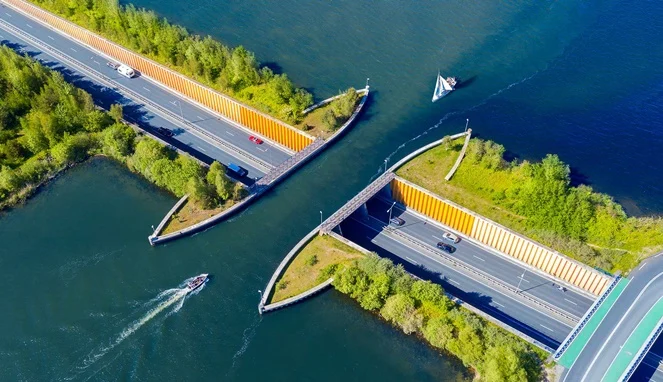
When civil engineers set out to design transportation networks, the standard paradigm usually involves building elevated overpasses or suspension bridges to carry vehicles safely above bodies of water. However, in the municipality of Harderwijk in eastern Netherlands, engineers flipped this conventional concept completely on its head. Completed and opened to the public in 2002, the Veluwemeer Aqueduct—locally known as Aqueduct Veluwemeer—stands as a testament to innovative infrastructure, allowing cars to drive beneath a navigable waterway while boats sail smoothly overhead. This architectural wonder has since evolved from a purely functional transportation solution into a globally recognized engineering landmark and a point of civic pride for the Netherlands.
Main Facts and Structural Overview
The Veluwemeer Aqueduct is situated in Harderwijk, connecting the mainland city to Flevoland, which notably ranks as the largest artificial island in the world. Rather than utilizing a traditional drawbridge or a high-clearance suspension bridge, Dutch civil engineers constructed a 25-meter-long and 19-meter-wide water bridge, beneath which sits a 17-meter-long underwater vehicular tunnel.
The aqueduct itself maintains a shallow depth of approximately 3 meters, which is precisely engineered to accommodate small watercraft, recreational boats, and leisure vessels traveling between the IJssel River and the Veluwemeer lake. Meanwhile, the submerged road tunnel beneath handles the heavy daily commute of roughly 8,000 motor vehicles. To ensure complete safety and prevent water from spilling over into the traffic lanes below, the edges of the water channel are reinforced with robust steel sheet piles and heavy-duty retaining walls. Additionally, the subterranean roadway features dedicated, protected pathways on both the left and right flanks, allowing pedestrians and cyclists to traverse the route securely away from automobile traffic.
Background Context and Chronology of Construction
The conception of the Veluwemeer Aqueduct was not driven by a desire to set architectural records, but rather out of strict logistical necessity. As the region of Flevoland continued to develop following its land reclamation from the IJsselmeer in the mid-to-late 20th century, traffic between the mainland and the new province surged exponentially.
Planning for a major transit corridor across the water body began in the late 1990s. Regional planners and transportation authorities faced a critical dilemma: how to facilitate uninterrupted traffic flow for both heavy terrestrial vehicles and commercial and recreational maritime vessels without causing massive bottlenecks. Traditional options, such as a swing bridge or a drawbridge, were heavily scrutinized. Engineers projected that a conventional bridge would cause severe traffic congestion every time a tall boat needed to pass, bringing vehicular movement to a frequent halt. Conversely, building a high-level suspension bridge would have required massive, costly approach ramps, disrupted the local landscape, and incurred exorbitant maintenance expenditures in a region characterized by a high water table and soft alluvial soils.
By opting for a navigable aqueduct paired with an underwater tunnel, planners bypassed these operational hurdles. Construction commenced near the turn of the millennium, and following intensive engineering oversight, rigorous hydrological testing, and meticulous structural implementation, the facility officially opened to traffic in 2002. The total construction expenditure reached approximately $61 million USD—a substantial fiscal investment at the time, yet one that transportation analysts subsequently validated as highly cost-effective when weighed against the long-term operational costs of staffing and maintaining mechanical drawbridges.
Engineering Analysis and Economic Implications
From a civil engineering and urban planning perspective, the Veluwemeer Aqueduct offers several distinct advantages over standard crossing methodologies. Most notably, it achieves continuous, uninterrupted flow for two entirely distinct modes of transportation: maritime and terrestrial. Waterborne vessels do not need to wait for traffic lights or bridge openings, and motorists do not experience delays caused by marine navigation schedules.

Furthermore, the integration of pedestrian and cycling infrastructure aligns seamlessly with the Netherlands’ broader national commitment to promoting non-motorized, active transport. The inclusion of protected multi-use paths ensures that residents living around Harderwijk and Flevoland can commute or engage in recreational travel safely.
From an economic standpoint, the project has reduced fuel wastage and minimized logistical friction associated with commuter delays. Although the initial capital outlay of $61 million was considerable, the absence of mechanical moving parts—which are prone to wear and tear, require continuous electrical power, and demand round-the-clock mechanical supervision—has drastically lowered long-term maintenance budgets for the regional water authority, Rijkswaterstaat.
Environmental Context and Regional Impact
Beyond its primary function as a transport nexus, the Veluwemeer Aqueduct is deeply embedded within a sensitive ecological and recreational landscape. The Veluwemeer lake functions not only as a hub for leisure activities such as sailing, windsurfing, and swimming for local residents and tourists, but it also serves as an important ecological buffer and cultural nature reserve supporting diverse local fauna and migratory bird species.
Flevoland, the artificial landmass serviced by the aqueduct, represents one of the most ambitious land reclamation projects in human history. Created by draining parts of the Zuiderzee through the Zuiderzee Works, Flevoland transformed former seabed into arable land and urban centers. The addition of the aqueduct infrastructure integrated this engineered island more firmly into the national Dutch highway network, supporting sustainable regional economic growth while preserving the hydrological integrity of the surrounding lakes and rivers.
Global Recognition and Cultural Significance
In the decades following its completion, the Veluwemeer Aqueduct transcended its utilitarian roots to become an internet phenomenon and an iconic symbol of Dutch engineering prowess. Aerial photographs and drone footage showing boats seemingly floating on a suspended highway above moving cars frequently circulate globally on digital platforms, drawing architecture enthusiasts, tourists, and infrastructure experts from around the world to Harderwijk.
Urban planning experts frequently cite the project as a prime example of context-sensitive design—a philosophy wherein infrastructure is tailored to harmonize with environmental realities rather than imposing artificial barriers upon them. By allowing water to cross over land without disrupting either domain, the aqueduct exemplifies the innovative problem-solving mindset that has characterized Dutch water management for centuries.
Ultimately, the Veluwemeer Aqueduct stands as a masterclass in modern civil engineering. By successfully harmonizing the demands of heavy road transport with the navigation rights of watercraft, the structure continues to serve as an enduring model for how complex geographical and logistical challenges can be met through visionary design, robust execution, and sustainable long-term planning.