The Architectural Marvel of Veluwemeer Aqueduct: How Netherlands Mastered Land and Water Engineering

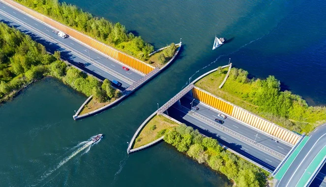
Engineering has long been defined by humanity’s persistent drive to conquer natural barriers, whether spanning deep canyons, tunneling through solid rock, or bridging vast expanses of open water. Traditional civil engineering solutions typically involve suspension bridges soaring high above shipping lanes or underground tunnels burrowing deep beneath riverbeds. However, in the low-lying nation of the Netherlands—a country where a significant portion of the land sits below sea level and water management is an existential art form—engineers have continually defied conventional paradigms. Among the nation’s most ingenious contributions to modern infrastructure is the Veluwemeer Aqueduct, a structure that fundamentally reimagines the intersection of road and waterway transport.
Located in the historic town of Harderwijk in eastern Netherlands, the Veluwemeer Aqueduct is not a bridge in the traditional sense, but rather a navigable aqueduct that allows vehicular traffic to pass underneath a continuous body of water. Opened to the public in 2002, this architectural masterpiece connects the mainland town of Harderwijk to Flevoland, a massive artificial island reclaimed from the IJsselmeer. From an aerial perspective, the structure presents a striking and paradoxical visual: automobiles appear to drive directly through a submerged path while boats glide smoothly overhead on a suspended layer of water. This unique design resolves a complex logistical challenge without relying on the costly and space-consuming ramps associated with high-level drawbridges, establishing a globally recognized benchmark for innovative water-land transit integration.
Background and Context of Dutch Water Management
To fully understand the significance of the Veluwemeer Aqueduct, one must examine the geographical and historical context of the Netherlands. Known historically for battling the North Sea and internal river flooding, Dutch civil engineering is rooted in necessity. The adage "God created the world, but the Dutch created the Netherlands" underscores the nation’s historic reliance on land reclamation, dikes, pumps, and sophisticated drainage networks.
Flevoland, the destination served by the aqueduct, represents one of the most ambitious feats in human geography. Created as part of the Zuiderzee Works—a vast engineering project designed to dam and reclaim parts of the Zuiderzee inlet—Flevoland is the largest artificial island in the world, meticulously carved out of the water and converted into arable land and residential zones. As the region developed throughout the late 20th century, transportation networks connecting Flevoland to the mainland required significant expansion. Planners faced a recurring dilemma: how to facilitate heavy vehicular traffic between Harderwijk and the newly established communities without disrupting the bustling commercial and recreational water traffic traversing the Veluwemeer lake and the IJssel river.
Traditional infrastructure options presented distinct disadvantages. A conventional drawbridge would cause frequent traffic congestion on the N302 roadway every time a sailboat or cargo vessel passed through. Conversely, a high-level suspension bridge would require massive approach ramps that would disrupt the flat Dutch landscape, consume valuable agricultural land, and incur exorbitant construction and maintenance costs. Consequently, regional authorities and civil engineers turned to an unconventional hydraulic architecture solution: a water aqueduct with a subterranean roadway tunnel.
Chronology and Construction Phase
The realization of the Veluwemeer Aqueduct was the culmination of extensive planning, environmental impact assessments, and rigorous structural testing. Conceptualized during the late 1990s as part of broader regional transit upgrades along the N302 corridor, the project broke ground with a mandate to balance economic efficiency, environmental preservation, and uninterrupted multimodal transport.
During the initial phase, engineers drained specific sections of the construction site using heavy-duty cofferdams and advanced pumping systems to allow excavation on dry ground. The project required precise coordination to ensure that the natural flow between the IJssel River and the Veluwemeer lake was maintained without destabilizing the surrounding water table.
Constructed over a period of several years, the final structure measures approximately 25 meters in length and 19 meters in width, maintaining a shallow water depth of roughly 3 meters. This specific depth was carefully calculated to accommodate small-to-medium vessels, recreational watercraft, and local commercial shipping while minimizing the dead load pressing down on the structural concrete box beneath. Steel sheet piling and reinforced retaining walls were integrated along the edges of the water channel to prevent overflow and ensure absolute structural integrity. Directly underneath, a 17-meter-wide submerged
roadway accommodates thousands of vehicles daily, flanked by dedicated, protected lanes for pedestrians and cyclists.

Financial Investment and Economic Efficiency
When evaluating large-scale civil engineering projects, cost-benefit analyses dictate municipal and national funding allocations. The total construction expenditure for the Veluwemeer Aqueduct reached approximately $61 million USD. While this figure represents a substantial capital investment, transport economists and urban planners have repeatedly highlighted its long-term cost-effectiveness compared to alternative proposals.
Building a high-level suspension bridge or an elevated viaduct capable of clearing large watercraft would have required extensive steel frameworks, massive clearance zones, and ongoing structural inspections subject to high wind loads—a persistent challenge in the flat, coastal plains of the Netherlands. Furthermore, the land acquisition costs for expansive bridge ramps would have significantly inflated the budget. By opting for a low-profile aqueduct that integrates seamlessly with the surrounding terrain, engineers avoided long-term maintenance liabilities associated with mechanical drawbridge components, hydraulic lifting motors, and cable corrosion.
Moreover, the uninterrupted flow of traffic has delivered continuous economic dividends. By eliminating bottlenecks for both vehicular commuters and marine navigation, the aqueduct prevents the fuel waste and productivity losses traditionally caused by idling cars at raised drawbridges and congested waterways.
Official Responses and Engineering Accolades
Upon its completion and official opening in 2002, the Veluwemeer Aqueduct drew widespread praise from international civil engineering associations, urban design councils, and environmental agencies. Dutch transport officials lauded the project as a triumph of pragmatic innovation, emphasizing that the structure exemplifies the nation’s core philosophy of living harmoniously with water rather than merely defending against it.
Civil engineering bodies commended the project team for managing complex geotechnical conditions, including soil settlement risks associated with reclaimed land. Structural safety was a primary focus during official evaluations; state transport authorities confirmed that the tunnel incorporates advanced drainage systems, continuous water-level monitoring sensors, and automated safety barriers to mitigate any remote risk of flooding or structural seepage.
Beyond its logistical utility, the project received acclaim from urban planners for its minimalist aesthetic footprint. Unlike towering bridges that visually dominate a landscape, the Veluwemeer Aqueduct maintains an open horizon, preserving the natural scenic vistas of the Dutch wetlands and rural countryside.
Broader Impact, Implications, and Tourism
In the decades since its inauguration, the Veluwemeer Aqueduct has transcended its original infrastructure mandate to become an iconic landmark and a point of civic pride in the Netherlands. While designed strictly for utility, the site has evolved into a notable point of interest for domestic and international travelers, frequently featured in global architecture documentaries and digital media for its visually arresting design.
The surrounding Veluwemeer lake functions not only as a vital shipping lane and recreational haven for windsurfers, boaters, and anglers, but also as a designated cultural nature reserve supporting diverse aquatic and avian fauna. The coexistence of high-speed vehicular traffic underneath a thriving natural wetland ecosystem highlights advanced ecological integration in modern civil design.
Furthermore, the success of the Veluwemeer Aqueduct has influenced contemporary infrastructure planning across Europe and beyond. As urban centers face increasing density and climate change introduces new water management challenges, hydraulic aqueducts and submerged multi-modal tunnels are increasingly considered viable alternatives to traditional highway bridging. The project demonstrates that when civil engineering harmonizes with unique geographic constraints, infrastructure can evolve from a mere utility into an enduring symbol of human ingenuity.