
Optimizing Group Travel Logistics Through Digital QR Code Integration for Seamless Navigation

The coordination of group travel, particularly involving multiple vehicles, independent transport providers, and dispersed accommodation, represents a recurring logistical challenge in the modern tourism sector. Recent reports from travel coordinators highlight that miscommunication regarding precise meeting points—often stemming from variations in digital mapping metadata across different mobile devices—frequently results in significant delays and resource mismanagement. To address these operational inefficiencies, organizers are increasingly adopting Quick Response (QR) code technology to bridge the gap between digital geolocation data and physical coordination.
The Logistical Challenge of Multi-Point Group Travel
In large-scale group outings, such as excursions to popular regional destinations like Puncak, Indonesia, the synchronization of ten or more participants across multiple rental vehicles necessitates a high degree of navigational precision. Traditional methods of sharing location data—typically via messaging applications—often fail when third-party personnel, such as hired drivers or local guides, are not integrated into the primary communication channels.
Field observations suggest that when coordinates or descriptive directions are manually relayed, they are susceptible to human error. Phrases such as "near the local market" or "take the left fork" are subject to subjective interpretation, leading to deviations in route selection. Furthermore, disparate smartphone operating systems and varying Google Maps API interpretations can cause pins to display differently across devices, leading to confusion. The implementation of standardized, static QR codes that encode specific geolocation links ensures that all parties—regardless of their technical literacy or group status—access identical, verified navigational data.
Technical Implementation: From Coordinates to Accessible Data
The process of converting geographic information into a scannable format relies on the transformation of URL structures into high-density matrix barcodes. By extracting the precise "share" link from a Google Maps pin, organizers can utilize open-source generators to create a QR code. This method is superior to standard address entry, as address-based searches are subject to a search engine’s real-time interpretation, which can occasionally result in inaccurate routing if the destination is remote or lacks a formal street address.
For areas with ambiguous geography, such as trailheads or rural homestays, experts recommend the use of "Plus Codes." These are alphanumeric sequences that function as a precise geographic identifier, ensuring that the navigation software points to the exact entrance of a facility rather than the centroid of a building, which might be blocked or inaccessible to vehicles.
Strategic Deployment and Best Practices
To maximize the efficacy of this system, organizers should adopt a tiered approach to documentation. Best practices involve creating individual, high-resolution QR codes for each critical stage of a journey.
- The Navigation Protocol: A dedicated card for the initial meeting point, secondary transit hubs, and final destination ensures a chronological flow.
- Resource Aggregation: QR codes linking to shared cloud storage, such as Google Drive, facilitate the collection of itinerary documents and collaborative photography. By setting access permissions to "Editor" status during the trip, organizers allow for real-time updates, though they must revert to "Viewer" status post-trip to prevent unauthorized deletion of shared media.
- Infrastructure Integration: Providing Wi-Fi credentials via QR codes reduces administrative friction at accommodations. These codes embed network names (SSID), password encryption types, and passwords, allowing guests to join networks instantaneously without manual input.
- Contact Management: Digital business cards containing contact information for local stakeholders, such as property owners or emergency service providers, should be formatted as vCard QR codes. This enables immediate saving of contact data to mobile address books, mitigating the risk of lost communication during network instability.
Data Security and Operational Risks
While the integration of QR technology enhances convenience, it necessitates an awareness of digital hygiene. Security analysts emphasize that shared folders should not contain sensitive personal data, such as passport copies, banking information, or private identification documents. Furthermore, the reliance on internet connectivity remains a limiting factor; while the QR code itself acts as a static gateway, the underlying Google Maps interface requires an active data connection to compute routes and provide real-time traffic updates.
From an administrative perspective, the "one-place-one-card" philosophy is essential. Consolidating too much data into a single code creates a bottleneck; if the link is broken or the server is inaccessible, the entire itinerary becomes unavailable. By maintaining physical, printed backups of these codes, organizers create a redundant system that remains functional even in the event of hardware failure or depleted battery life.

Broader Industry Implications
The transition toward digital-first logistical management reflects a broader shift in the tourism and hospitality industry. As travelers increasingly demand friction-less experiences, the ability for hosts and tour operators to provide clear, scan-to-access information has become a competitive advantage.
Research indicates that destinations utilizing standardized digital wayfinding significantly reduce the time spent on "last-mile" navigation. For transportation providers, the ability to scan a code that immediately populates a GPS route reduces the likelihood of driver fatigue and fuel waste caused by incorrect turn-offs. Moreover, for the event management sector, the standardization of these protocols allows for more scalable operations. As the volume of group travel continues to grow in emerging markets, the use of QR-integrated navigation is expected to become the industry standard for both independent travelers and professional tour coordinators.
Summary of Deployment Requirements
To ensure a successful transition to this system, organizers should adhere to the following technical checklist:
- Format Selection: Use PNG formats for digital display on mobile devices, and vector (SVG) or PDF formats for printed materials to ensure clarity at varying scales.
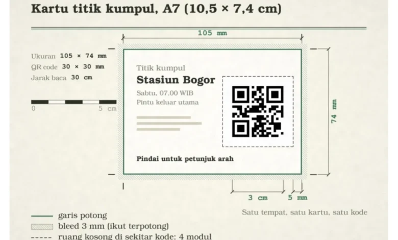
- Dimensionality: For printed cards, a QR code size of approximately 3 centimeters is sufficient for most standard scanning distances.
- Pre-Departure Testing: Always test codes from a device that is geographically distant from the destination to ensure the link redirects correctly to the intended coordinates rather than the scanner’s current location.
- Static vs. Dynamic: Be aware that if a destination changes, a static QR code cannot be updated. Organizers must be prepared to replace outdated physical cards with new, corrected versions.
As digital tools become more deeply embedded in the travel experience, the reliance on archaic, manual instructions is rapidly diminishing. By leveraging the universality of QR technology, group travelers can minimize the common frictions of coordination, allowing for a more focused and efficient travel experience. While the technology is simple in its execution, its impact on operational efficiency—particularly in high-traffic, multi-vehicle scenarios—is substantial, marking a significant evolution in how groups navigate the modern landscape.