
Earth from Above: Ten Geological Wonders and Phenomenal Sights Captured by Satellite Imagery

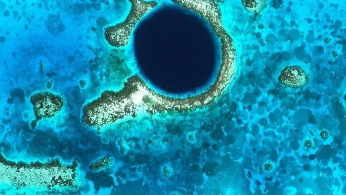
The perspective provided by satellite technology has fundamentally transformed our understanding of Earth’s surface, offering a bird’s-eye view of phenomena that are otherwise difficult to comprehend from the ground. From the depths of the ocean to the shifting dunes of the desert and the expansive reach of space, modern orbital sensors allow scientists and the public alike to witness the dynamic evolution of our planet. This compilation examines ten distinct locations and events, highlighting the geological processes, ecological shifts, and celestial mechanics that shape the world we inhabit.
The Great Blue Hole: A Submerged Geological Relic
Located near the center of Lighthouse Reef, approximately 70 kilometers off the coast of Belize, lies the Great Blue Hole, a near-perfect circular marine sinkhole that serves as a testament to Earth’s fluctuating sea levels. Spanning roughly 300 meters in diameter and reaching a depth of 125 meters, the site was not always submerged. During the Quaternary glaciation periods, when sea levels were significantly lower, this site functioned as a dry limestone cave system. As the glaciers melted and sea levels rose, the cave was flooded, and its roof eventually collapsed, creating the massive vertical shaft visible today. Now a protected World Heritage Site and a premier destination for global diving expeditions, the Blue Hole provides researchers with critical data regarding historical climate patterns through the analysis of stalactites and stalagmites preserved within its depths.
The Hara Forest: A Vital Coastal Ecosystem
Nestled between Qeshm Island and the southern mainland of Iran, the Hara Forest represents the largest mangrove ecosystem in the Persian Gulf. Characterized by a complex network of turquoise water channels, these forests are essential to the regional maritime biology. Since its formal designation as a protected area in 1972, the Hara Forest has served as a sanctuary for diverse avian species, including flamingos, pelicans, and herons. The dense root systems of the Avicennia marina—the dominant mangrove species—act as a natural filter and a nursery for marine life, attracting green sea turtles that frequent the area for sustenance. The ecological stability of this region remains a focal point for conservationists tasked with balancing industrial shipping traffic in the Persian Gulf with the preservation of sensitive coastal habitats.
Volcanic Reawakening at Titan Ridge
On May 8, 2026, the quietude of the Bismarck Sea was interrupted by a series of seismic events, signaling the reawakening of a long-dormant submarine volcano. Within 24 hours of the initial tremors, satellite monitoring systems identified a massive plume of steam rising nearly 3 kilometers above the ocean surface, approximately 125 kilometers southeast of Manus Island. Geologists have attributed this activity to the Titan Ridge, a volcanic feature that had shown little to no activity in recent historical records. The rapid detection of this eruption underscores the importance of remote sensing in managing maritime safety. Authorities in Papua New Guinea issued regional alerts to warn local vessels of potential volcanic debris and water-temperature shifts, demonstrating the necessity of integrated monitoring networks in volatile tectonic zones.
Celestial Mechanics: The Himawari-9 Perspective
On October 23, 2026, at 00:20 UTC, the Japanese Himawari-9 weather satellite captured a rare visual alignment. Positioned in a geostationary orbit roughly 35,800 kilometers above the equator, the satellite is designed to image the entire planetary disk every ten minutes. During this routine observation, the Moon was captured crossing the edge of the satellite’s field of view. While the visual depth of the image suggests proximity, the Moon remains approximately 384,000 kilometers from Earth. Such imagery is more than a curiosity; it serves to calibrate the satellite’s sensors and provides scientists with updated data on planetary albedo—the measure of how much sunlight the Earth reflects back into space—which is a critical variable in long-term climate modeling.
The Ugab River and the Namibian Landscape
The northwest region of Namibia presents a landscape so arid and geologically distinct that it often draws comparisons to the Martian surface. Utilizing false-color satellite imagery, researchers have mapped the winding path of the Ugab River as it traverses this barren terrain. The colors seen in these satellite captures are not visible to the naked eye but are the result of processed multispectral data, highlighting mineral concentrations and varying rock densities. This region is of particular interest to geologists studying the erosion processes in hyper-arid environments, as the exposed strata provide a clear, uninterrupted record of geological history spanning hundreds of millions of years.
The Flinders Ranges: A Study in Mineral Diversity
In the northern reaches of the Flinders Ranges, located approximately 480 kilometers north of Adelaide, Australia, satellite sensors have revealed a psychedelic array of colors. This 1,257-square-kilometer area is a geological archive, where folded rock layers from the Neoproterozoic era have been thrust to the surface. The distinct hues observed in false-color imagery correspond to the varying mineralogical compositions of the rock formations, ranging from ancient sandstones to siltstones. The Flinders Ranges serve as an outdoor laboratory for earth scientists, offering insights into the tectonic forces that shaped the Australian continent and the historical climate conditions that deposited these distinct geological layers.
The Richat Structure: The Eye of the Sahara
Often referred to as the "Eye of the Sahara," the Richat Structure in Mauritania is a prominent geological feature with a diameter of nearly 40 kilometers. Formed approximately 100 million years ago, the structure is a deeply eroded geologic dome. Magmatic activity originally pushed the earth’s crust upward without breaching the surface; over subsequent eons, differential erosion acted upon the varied rock layers. Harder, more resistant quartzites remained as concentric ridges, while softer rocks were eroded into valleys, creating the characteristic bullseye pattern. Beyond its geological significance, the feature is a well-known navigational waypoint for astronauts, who have utilized its unique shape as a reference point since the dawn of human spaceflight.
The Giza Plateau: A Legacy of Ancient Engineering
Satellite imagery provides a comprehensive overview of the Giza Plateau, documenting the precise arrangement of the Great Pyramid of Khufu, the Pyramid of Khafre, and the Pyramid of Menkaure, alongside smaller queen pyramids and the surrounding necropolis. Constructed approximately 4,500 years ago, the Great Pyramid held the title of the tallest human-made structure for nearly 38 centuries. Satellite analysis confirms that the sides of the structures are aligned with near-perfect accuracy to the cardinal points, a testament to the sophisticated engineering capabilities of the Old Kingdom of Egypt. Today, high-resolution satellite data is being used by archaeologists to map subterranean chambers and identify potential undiscovered structures within the plateau without the need for invasive excavation.
Cyanobacteria Blooms in the Baltic Sea
The island of Gotland, Sweden’s largest island, is frequently surrounded by swirling, marble-like patterns visible from orbit. These patterns are not geological but biological: they represent massive blooms of cyanobacteria, commonly known as blue-green algae, which occur in the Baltic Sea during the warmer summer months. These blooms are fueled by nutrient runoff, particularly phosphorus and nitrogen, which trigger rapid growth. While these events are natural, their increasing frequency and intensity have become a subject of concern for Baltic environmental agencies. Satellite monitoring allows authorities to track the movement and density of these blooms, which can produce toxins harmful to marine life and local water quality, thereby facilitating timely responses to potential environmental hazards.
The Gombe Stream: A Sanctuary of Biodiversity
In the Western Rift Valley of Tanzania, the dark waters of Lake Tanganyika contrast sharply with the vibrant, forested ravines of the Gombe Stream National Park. Despite its small size—covering only 20 square miles—the park is of immense ecological importance. It is a critical habitat for the chimpanzee populations made famous by the research of Jane Goodall. The satellite view emphasizes the park’s isolation as an "island" of biodiversity, surrounded by areas that have undergone significant agricultural transformation. The imagery highlights the ongoing challenges of conservation in East Africa, where protected zones must be carefully managed to ensure the survival of endemic species amidst a changing landscape.
Implications for Global Monitoring
The ability to observe these ten sites from orbit illustrates the dual nature of modern satellite technology: it provides essential scientific data for climate and geological research while simultaneously offering a perspective that fosters a deeper public appreciation for the planet’s complexity. As sensor technology continues to advance, the resolution and frequency of these observations will improve, allowing for more precise tracking of natural disasters, ecological degradation, and long-term environmental changes. Whether identifying a volcanic eruption in the remote Bismarck Sea or monitoring the health of a forest in Iran, the view from above remains one of the most effective tools for stewardship in an era of rapid planetary change.