Revolutionizing Group Travel Logistics Through Digital QR Code Integration for Seamless Navigation and Information Management

The complexities of coordinating group travel, particularly when dealing with fragmented communication channels and multiple logistics providers, have long been a source of inefficiency and potential error. Recent field observations involving a ten-person travel party navigating the Puncak region of Indonesia highlighted a modern solution to these logistical hurdles: the systematic deployment of Google Maps-linked QR codes. By converting geographical coordinates and digital assets into scannable barcodes, organizers have effectively streamlined the interaction between travelers, transport providers, and venue hosts.
The Logistical Challenge of Group Coordination
Travel dynamics involving large groups often suffer from "information asymmetry," where different members possess conflicting location pins, outdated itineraries, or miscommunicated contact details. In the case of the Puncak excursion, the group managed two separate rental vehicles and a decentralized accommodation arrangement. The primary friction points included a driver who lacked access to the internal group chat and inconsistent digital mapping data across multiple smartphones.
In a professional logistics context, reliance on verbal directions—such as "turn left near the market"—is prone to subjective interpretation. Research into navigational accuracy confirms that geographical pinned locations provided via digital platforms offer a significantly higher success rate in reaching precise destinations compared to traditional address-based search methods, which often lead to residential errors or navigation to building centers rather than specific entry points.
Methodology: From Digital Link to Physical Utility
The implementation of QR technology in this travel scenario followed a structured digital-to-physical workflow. Organizers utilized freely available QR generation software to convert Google Maps URLs, Google Drive links, and Wi-Fi configuration strings into high-contrast, scannable formats.
The technical process involves several key stages:
- Verification of Coordinates: Before code generation, the exact point of entry—specifically the guest entrance rather than a building’s administrative center—is pinned on the map.
- Link Conversion: The verified URL is processed through a QR generator. For locations lacking precise street addresses, such as remote trailheads, the use of Google Plus Codes is prioritized to ensure a singular, immutable reference point.
- Format Optimization: For mobile-based display, PNG files are generally sufficient. However, for printed physical cards—often affixed to vehicle dashboards or common areas—SVG (Scalable Vector Graphics) or PDF formats are required to maintain clarity during enlargement and printing.
Chronological Implementation and Strategic Use
The success of this strategy relies on the organized staging of information. During the Puncak trip, the itinerary was structured into a series of physical "information cards." The protocol was as follows:
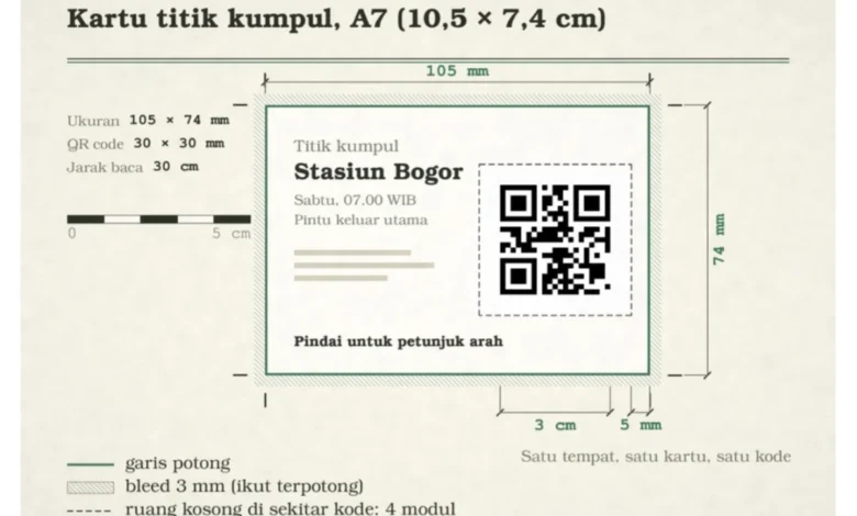
- Pre-Departure: The assembly point at Bogor Station was designated as the primary code, distributed to all participants and transport providers.
- Transit: Each rental vehicle was equipped with a physical card containing the destination pin for the villa and designated dining stops. This eliminated the need for drivers to interrupt their route to request navigational clarification.
- Arrival: Upon arrival at the accommodation, a pre-generated Wi-Fi QR code—containing the SSID, encryption type, and password—allowed guests to connect instantly without the manual entry of credentials.
Analytical Perspectives on Digital Accessibility
The shift toward QR-based information sharing is supported by broad digital trends. With the integration of native QR scanning into camera applications for both iOS and Android (via Google Lens), the barrier to entry for non-technical users has been virtually removed.
Industry analysts observe that this approach significantly reduces the time spent on administrative inquiries. By centralizing shared resources—such as collaborative photo galleries or itinerary documents—in a cloud-based folder (Google Drive) accessed via a single QR code, the burden of "information hunting" is mitigated. Furthermore, by adjusting permission settings from "Editor" to "Viewer" post-trip, organizers ensure the integrity of the collected data, preventing accidental deletions or unauthorized modifications.

Implications for Tourism and Hospitality
The broader impact of this technological adoption suggests a paradigm shift in how travel and hospitality services should manage guest logistics. For property managers, providing a standardized QR code that directs guests to the precise entrance of a villa or hotel—rather than a generic neighborhood pin—can reduce guest dissatisfaction and operational overhead related to navigational support.
Furthermore, the practice of creating "contact cards" for essential personnel, such as drivers, local guides, or emergency services, provides a fail-safe mechanism. By encoding contact details into a QR format, travelers can instantly save professional information to their device address books, reducing the risk of manual input errors.
Constraints and Best Practices
Despite the efficiency gains, the system is not without limitations. Most notably, static QR codes are tethered to the original URL. Should a location change or an itinerary be significantly modified, the physical cards become obsolete. Consequently, the reliance on digital, cloud-hosted documents that can be updated in real-time while maintaining a static QR link is the recommended professional standard.
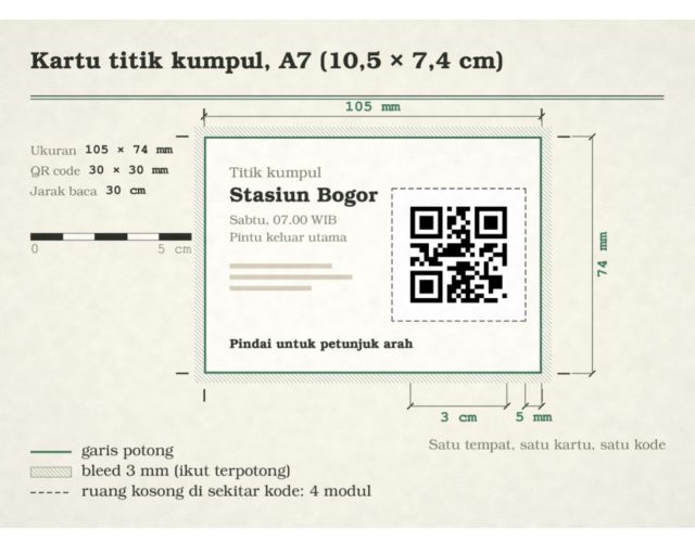
For optimal performance, the following technical criteria are essential:
- Size Standardization: A minimum physical size of 3cm is recommended for a 1:10 scan-distance-to-size ratio, ensuring readability under various lighting conditions.
- Testing Protocols: Verification must be conducted using a device external to the primary organizer’s network to confirm that the map pin resolves correctly for third-party users.
- Browser Compatibility: It is standard for Google Maps to open in a mobile browser if the native application is not invoked; however, the functional utility of the navigational prompts remains consistent across both environments.
Conclusion
The integration of QR code technology into the travel experience serves as a practical application of existing digital tools to solve age-old logistical problems. By transitioning from fragmented verbal instructions to structured, scannable data points, the Puncak group effectively eliminated navigation errors and streamlined the coordination of ten individuals across multiple transit points. As tourism continues to prioritize efficiency and digital autonomy, the adoption of standardized QR-based information hubs is likely to become an expected service, particularly for independent travel groups and rental property management.
While the technology is inherently simple, its efficacy is contingent upon the meticulous preparation of data—ensuring that pins are accurate, links are accessible, and permissions are correctly configured. As demonstrated, the transition from "getting lost in the neighborhood" to "seamless navigation" is merely a matter of a well-executed scan.