The Engineering Marvel of Veluwemeer Aqueduct: How the Netherlands Bypassed Conventional Infrastructure With Water Bridges

Bridges have historically served as fundamental pillars of human civilization, designed primarily to bridge geographical divides and facilitate the seamless movement of pedestrians, cyclists, and motorists across treacherous terrains or vast bodies of water. Conventionally, infrastructure designers and civil engineers approach these crossings with a standardized methodology: elevated roadways resting upon concrete piers or suspension cables spanning over navigable waterways. However, in the Netherlands—a nation renowned for its centuries-long mastery of water management, land reclamation, and innovative hydro-engineering—traditional approaches are frequently challenged by unique geographical constraints. Among the country’s most striking contributions to modern civil engineering is the Veluwemeer Aqueduct, a structure that defies conventional visual logic by allowing automotive traffic to pass beneath a navigable body of water.
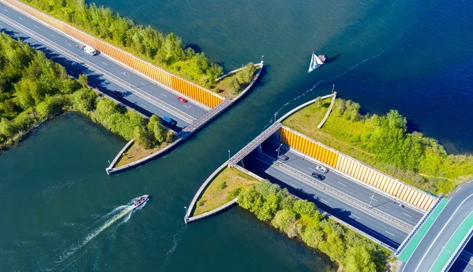
Located in the historic town of Harderwijk in the eastern province of Gelderland, the Veluwemeer Aqueduct is a triumph of spatial planning and functional design. Viewed from an aerial perspective, the structure presents an arresting optical illusion: a continuous stream of automobiles appears to drive directly through the middle of a lake, neatly splitting the body of water in two. Far from being a mere novelty or an aesthetic statement, this architectural marvel represents a sophisticated, highly calculated solution to a complex transportation dilemma, effectively balancing the demands of heavy highway traffic with the imperative of maintaining uninterrupted commercial and recreational water routes.
Main Facts and Structural Anatomy of the Aqueduct
The Veluwemeer Aqueduct, officially opened to the public in 2002, forms an integral part of the N302 roadway. Structurally, the water bridge measures approximately 25 meters in length and 19 meters in width, maintaining a deliberate and shallow water depth of just 3 meters. This specific depth is meticulously engineered to accommodate small watercraft, recreational boats, and leisure vessels safely without necessitating the installation of complex, energy-intensive, and time-consuming lock systems.
Directly beneath this flowing body of water lies a subterranean highway tunnel spanning 17 meters in length. The transition from open-air roadway to the underwater corridor is engineered with strict adherence to modern safety standards. Steel sheet piles and robust retaining walls line the perimeter of the water channel, ensuring absolute hydrological containment and preventing any risk of water spilling into the sunken vehicular tunnel below. Furthermore, the subterranean section features dedicated, protected lanes flanking the main vehicular route on both sides, specifically designated for pedestrians and cyclists. These pathways are equipped with high-grade security barriers and reinforced railings, ensuring that non-motorized commuters can traverse the route safely while remaining completely shielded from passing vehicular traffic.
Chronology and Development: The Genesis of a Hydro-Engineering Solution
The conceptualization and eventual construction of the Veluwemeer Aqueduct emerged from a critical need to modernize regional transportation corridors while accommodating the expansive land development policies of the Dutch government. During the late 20th century, regional planners in Gelderland and the newly established province of Flevoland faced a mounting logistical challenge. Flevoland, reclaimed entirely from the IJsselmeer as part of the ambitious Zuiderworks project, had rapidly evolved into one of the largest artificial islands in the world. As agricultural, residential, and commercial developments flourished on the reclaimed land, connectivity between the mainland town of Harderwijk and Flevoland became paramount.
Initial proposals considered a variety of conventional infrastructure models to link the two regions, including high-level suspension bridges and traditional drawbridges. However, engineers quickly realized that a conventional high-level bridge would require massive approach ramps, imposing a heavy visual and spatial footprint upon the surrounding flat landscape, while a drawbridge would inevitably create severe traffic bottlenecks for the thousands of motorists commuting daily along the N302, as well as delays for maritime traffic navigating between the IJssel Lake system and inland waterways.
Following extensive feasibility studies, regional authorities and civil engineering firms opted for the aqueduct concept. Construction commenced in the late 1990s, culminating in the official inauguration of the Veluwemeer Aqueduct in 2002. The total capital expenditure for the project amounted to approximately $61 million USD. Although this financial figure represented a substantial initial investment, cost-benefit analyses confirmed that constructing an aqueduct combined with a submerged vehicular tunnel was significantly more cost-effective and operationally sustainable over its lifecycle than building and maintaining a major multi-lane swing bridge or a high-clearance suspension structure capable of handling large maritime vessels.

Supporting Data and Operational Capacity
Since its completion more than two decades ago, the Veluwemeer Aqueduct has operated with remarkable efficiency, serving as a critical nexus for both regional commuting and leisure navigation. Statistical data compiled by Dutch transport authorities indicates that the subterranean highway tunnel beneath the aqueduct handles an average daily traffic volume of approximately 8,000 vehicles, ranging from private passenger cars to heavy freight and commercial transport trucks.
Simultaneously, the upper water channel facilitates steady maritime traffic. The Veluwemeer—a border lake situated between the provinces of Gelderland and Flevoland—connects directly with the meandering waters of the IJssel River. During the peak spring and summer tourism seasons, the aqueduct accommodates hundreds of recreational boats, yachts, and touring vessels daily. The dual-layer design ensures zero waiting times for either motorists or sailors, completely eliminating the friction points traditionally associated with movable bridges where land and water routes intersect.
Official Responses and Societal Implications
The realization of the Veluwemeer Aqueduct drew widespread acclaim from urban planners, environmental scientists, and civil engineering bodies across Europe. Government officials in Harderwijk and representatives from Rijkswaterstaat (the executive agency of the Dutch Ministry of Infrastructure and Water Management) frequently cite the project as a textbook example of future-proof infrastructure planning that respects both human mobility needs and ecological integrity.
From an environmental and ecological perspective, the integration of the aqueduct generated minimal disruption to the delicate hydrology of the Veluwemeer and the surrounding wetland ecosystems. The lake functions not only as a vibrant recreational hub for swimming, sailing, and windsurfing but also as an officially designated cultural and natural reserve providing critical habitats for indigenous aquatic fauna and migratory bird species. By directing vehicular traffic underground, noise pollution at the water’s surface is significantly reduced, preserving the acoustic and ecological tranquility of the natural reserve.
Broader Economic and Global Significance
The broader implications of the Veluwemeer Aqueduct extend far beyond its immediate utility as a regional transit link. As global climate change and rising sea levels prompt nations worldwide to rethink water management and coastal infrastructure, the Dutch model of living with water rather than merely fighting against it has garnered intense international interest. Water bridges and aqueducts, once viewed as rare architectural anomalies, are increasingly being studied by urban planners in densely populated delta regions across Asia and North America.
Furthermore, the structure has achieved iconic status within the global architecture and tourism sectors. Often featured in international documentaries, engineering journals, and travel publications, the Veluwemeer Aqueduct attracts thousands of engineering enthusiasts, tourists, and photographers annually, all eager to witness firsthand the illusion of ships sailing serenely above speeding cars.
In summary, the Veluwemeer Aqueduct stands as a testament to human ingenuity and the power of multidisciplinary engineering. By reimagining the traditional intersection of land and water transport, the Netherlands successfully delivered a safe, cost-effective, and visually arresting solution that continues to serve as an enduring benchmark for modern infrastructure development worldwide.